Written by Keun Lee
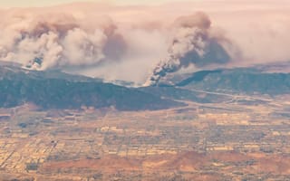
California under fire
Just this year, California went through yet another tragedy causing billions of dollars in damages, loss of homes, loss of life, and displaced families. Every year on this side of the coast, for as long as I can remember, this tragedy occurs on repeat! I see and hear about emergency responders responding to these situations and more often than not, "time" is NOT on our side. I see and hear about what happens "after the fact," and that is troubling. The imagery that I see captured in the media depicts what quite literally looks like "hell on earth."
As an engineer, I desire a logical solution to combat this problem. So let's take a step back.
I'm interested in finding out how to increase "situational awareness," because:
- The sooner you obtain awareness, then the sooner you can respond
- The sooner you can respond, then the more options you have on the table
- The more options you have, then the better opportunity you have to make life-saving decisions
Let's face it, a spreading fire left unchecked waits for nobody. How do we go about changing parameters to increase awareness? We have the necessary maps, GIS, and spatial data to determine where these events happen. We usually get this data after the fact:
- What if we could get this data in real-time?
- What if we could improve our timing of realization and awareness?
- What if we could:
- get a glimpse of what spatial data looked like in the infrared, in real-time, and report:
- Areas in trouble
- Rate of spread
- Homes affected
- Homes at risk
- And calculate a logical risk priority order of where to put fires out, because let's face it, human beings themselves are slow at calculating risk.
- get a glimpse of what spatial data looked like in the infrared, in real-time, and report:
Could you imagine, what we could do with just that as it is happening?
"Man often becomes what he believes himself to be. If I keep on saying to myself that I cannot do a certain thing, it is that I may end by really becoming incapable of doing it. On the contrary, If I have the belief that I can do it, I shall surely acquire the capacity to do it, even if I may not have it at the beginning." - Gandhi
I think Gandhi said this because he made these particular observations, made sense of it, believed in it, and stated it.
Technologically, we're not that far away from achieving this kind of awareness and decision making, via AI, Machine Learning, and/or Pattern Recognition.
Chicago under the gun
Just in 2017, there have been over 3,000 recorded shootings in Chicago. And that does not include the shootings that haven't been reported. If you were to take every documented shooting in Chicago this year and punched a hole on a paper map for every shooting, almost all of Chicago would be blotted out. You'd be missing the South and West sides because they'd be on the floor as confetti.
With all the data that we can collect on each shooting, specifically the where and the when you still have to deal with the case that this data is conceived after the fact after an unspecified amount of time-delay.
We're able to discern at least where violent gun crimes are most concentrated, but how do you capture that in real-time and respond fast enough to save lives potentially? Or even possibly catch an assailant or suspect?
Interestingly enough, when I was coming up with the topics and use cases for this entry, I spoke of it to my CEO, J Schwan over at Solstice. He enlightened me to the fact, that an active software system was in development and deployable for emergency responders, utilizing Sensors, IoT, GIS, Mobile, and Cloud Native Technologies to create situational awareness of what's going on in real-time. That product can be found here: http://www.shotspotter.com/
We have the technology
There's no question that we have the tools and infrastructure to make these things happen. Some of those tools can be leveraged from what we already know within the Spring Ecosystem (to name a few):
- Spring Boot
- Spring Cloud Streams
- Spring Cloud Data Flow
Other tools can be leveraged for near real-time messaging and processing (to name a few):
- Apache Kafka
- Apache Spark
- Apache Storm
- RabbitMQ
Put this all on a robust, scalable platform such as Pivotal Cloud Foundry (PCF) and result in an accurate account of spatial data as a source of truth, along with advocacy and usage.
With the use of these tools and related building blocks, it is not outside the realm of possibility to achieve systems capable of quickly communicating "Situational Awareness."


